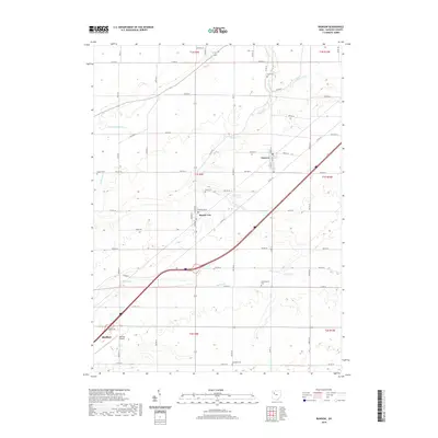
2019 Map of Rawson
USGS Topo · Published 2019About this map
Rawson and Mount Cory serve as central points in this Hancock County landscape, where the agricultural grid is defined by a dense network of township and county roads. The terrain is marked by the winding course of Ottawa Cr and several drainage systems like Homer Green Ditch and Marsh Run, which have historically shaped the farming potential of the region. This 2019 survey reflects a modern view of the area, yet it remains a vital resource for genealogists due to the clear marking of several rural burial sites, including Flick Cem, Clymer Cem, and Cannonsburg Cem. To the southwest, the growth of Bluffton is visible, including the Bluffton Airport and residential developments along Navajo Dr, illustrating the gradual expansion of the village toward the surrounding township lands.
Find a feature on this map
46 named features on this map. Tap any name to fly to it.
Don’t see what you’re looking for? This feature index may not catch every label — zoom into the map to look around manually.
Map Details
Editions of this 2019 Rawson Map
This is the sole edition of this map. No revisions or reprints were ever made.
Other maps of this area

1903 · Findlay
USGS Topo · 1:62,500

1905 · Arlington
USGS Topo · 1:62,500

1907 · Bluffton
USGS Topo · 1:62,500

1907 · Arlington
USGS Topo · 1:24,000

1950 · Marion
USGS Topo · 1:250,000

1956 · Toledo
USGS Topo · 1:250,000

1960 · Bluffton
USGS Topo · 1:24,000

1960 · Rawson
USGS Topo · 1:24,000

1960 · Arlington
USGS Topo · 1:24,000
1960 · Leipsic
USGS Topo · 1:24,000