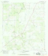
1965 Map of Ray Point
USGS Topo · Published 1969About this map
The Bee Co Live Oak Co line divides this South Texas landscape, where the confluence of several creeks defined local life in the mid-1960s. Sulphur Creek and Mustang Creek wind through the terrain, joined by smaller tributaries like Big Well Creek and Salt Creek. The small community of Ray Point serves as a focal point near the southern edge, identified by its cluster of Cemeteries and local road network. Further north, the settlement of Oaks sits along the roadway near Wernli Cem, reflecting the early rural development of the region.
Find a feature on this map
23 named features on this map. Tap any name to fly to it.
Don’t see what you’re looking for? This feature index may not catch every label — zoom into the map to look around manually.
Map Details
Editions of this 1965 Ray Point Map
2 editions found
Other maps of this area

1920 · Mikeska
USGS Topo · 1:125,000

1927 · Oakville
USGS Topo · 1:62,500

1936 · Pettus
USGS Topo · 1:62,500

1953 · Crystal City
USGS Topo · 1:250,000

1953 · Beeville
USGS Topo · 1:250,000

1954 · Fleming
USGS Topo · 1:62,500

1955 · Crystal City
USGS Topo · 1:250,000

1956 · Suniland
USGS Topo · 1:62,500

1956 · Beeville
USGS Topo · 1:250,000

1956 · Pettus
USGS Topo · 1:62,500