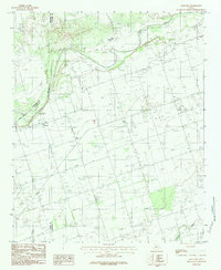
1983 Map of Rayland
USGS Topo · Published 1984About this map
Pease River defines the northern landscape of this Texas ranching region, its broad sandy channel cutting through the plains where Hardeman and Wilbarger counties meet. The small community of Rayland serves as the primary settlement, positioned near the historic Antelope Springs. The map reveals a rural economy dependent on subterranean resources, evidenced by numerous wells and a prominent pipeline traversing the southern portion of the quadrangle. Beyond the river bluffs, the terrain flattens into agricultural tracts marked by local landmarks like Parsley and the drainage of Paradise Creek. This 1983 record preserves the distribution of homesteads and small family burial plots, such as the local Cem, reflecting the sparse but enduring settlement patterns of North Texas.
Find a feature on this map
10 named features on this map. Tap any name to fly to it.
Don’t see what you’re looking for? This feature index may not catch every label — zoom into the map to look around manually.
Map Details
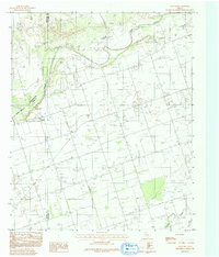
Editions of this 1983 Rayland Map
2 editions found
Other maps of this area

1954 · Wichita Falls
USGS Topo · 1:250,000

1955 · Lawton
USGS Topo · 1:250,000

1958 · Wichita Falls
USGS Topo · 1:250,000

1958 · Vernon
USGS Topo · 1:62,500

1958 · Medicine Mound
USGS Topo · 1:62,500

1966 · Santa Rosa Lake
USGS Topo · 1:24,000

1966 · Thalia
USGS Topo · 1:24,000
1966 · Santa Rosa Lake NW
USGS Topo · 1:24,000

1983 · Warrior Hollow
USGS Topo · 1:24,000

1983 · Tolbert
USGS Topo · 1:24,000