
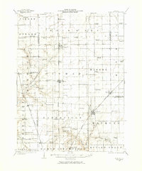
1923 Map of Raymond
USGS Topo · Published 1965About this map
The agrarian heart of Central Illinois is meticulously documented during the early 1920s, revealing a landscape defined by an exceptionally dense network of one-room schoolhouses and rural meeting places. Settlements such as Raymond and Farmersville serve as regional hubs, while the surrounding townships like Bois D'Arc and Zanesville are dotted with family-named or local landmarks, including the Studebaker School and Boston Chapel School. This era was the height of the decentralized education system, where a school or church like Blue Mound Church was situated every few miles to serve the surrounding farmsteads.
Find a feature on this map
78 named features on this map. Tap any name to fly to it.
Don’t see what you’re looking for? This feature index may not catch every label — zoom into the map to look around manually.
Map Details
Editions of this 1923 Raymond Map
2 editions found
Other maps of this area

1912 · Gillespie
USGS Topo · 1:62,500

1915 · Gillespie
USGS Topo · 1:62,500

1915 · Mount Olive
USGS Topo · 1:62,500

1922 · Divernon
USGS Topo · 1:62,500

1923 · Carlinville
USGS Topo · 1:48,000

1923 · Taylorville
USGS Topo · 1:62,500

1924 · Divernon
USGS Topo · 1:62,500

1924 · Waverly
USGS Topo · 1:62,500

1925 · Taylorville
USGS Topo · 1:62,500

1925 · Carlinville
USGS Topo · 1:62,500