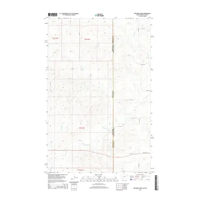
2014 Map of Red Bank Creek
USGS Topo · Published 2014About this map
Red Bank Creek and Little Muddy Creek converge in this corner of the High Plains, where the state boundary between Montana and North Dakota meets the local division of Roosevelt and Williams counties. The landscape is defined by the drainage patterns of these creeks, which carve subtle relief into the prairie. The transportation network is anchored by Us-2 in the southern portion of the map, which serves as a primary east-west corridor for the region. A grid of section roads, including CR-1004, 49th St NW, and 153rd Ave NW, provides access to the surrounding agricultural and ranch lands. This survey captures the rural character of the borderlands before any significant modern development, emphasizing the relationship between the natural watercourses and the human-imposed township and range grid system.
Find a feature on this map
18 named features on this map. Tap any name to fly to it.
Don’t see what you’re looking for? This feature index may not catch every label — zoom into the map to look around manually.
Map Details
Editions of this 2014 Red Bank Creek Map
This is the sole edition of this map. No revisions or reprints were ever made.
Other maps of this area

1953 · Williston
USGS Topo · 1:250,000

1954 · Wolf Point
USGS Topo · 1:250,000

1957 · Williston
USGS Topo · 1:250,000

1958 · Wolf Point
USGS Topo · 1:250,000

1968 · Trenton SW
USGS Topo · 1:24,000

1968 · Bainville SE
USGS Topo · 1:24,000

1969 · Bainville SW
USGS Topo · 1:24,000

1974 · Red Bank Creek
USGS Topo · 1:24,000

1974 · Bonetraill SW
USGS Topo · 1:24,000
1974 · Trenton NW
USGS Topo · 1:24,000