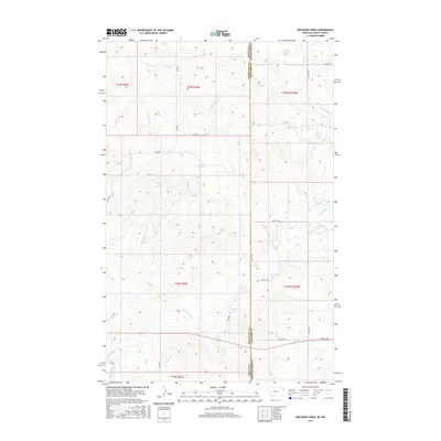
2017 Map of Red Bank Creek
USGS Topo · Published 2017About this map
Red Bank Cr and Little Muddy Cr define the drainage patterns of this high plains landscape at the border of Montana and North Dakota. This 2017 survey captures the intersection of the Roosevelt County and Williams County line with the state boundary, illustrating how the rectilinear Public Land Survey System imposes order over the undulating topography. The map detail highlights a network of rural section roads, including north-south corridors like 156th Ave NW and 154th Ave NW, which connect isolated homesteads and agricultural tracts across townships t29n r59e and t155n r104w. The arrangement of these roads, such as 57th St NW and 50th St NW, reflects the enduring legacy of 19th-century land division in the contemporary geography of the American West.
Find a feature on this map
22 named features on this map. Tap any name to fly to it.
Don’t see what you’re looking for? This feature index may not catch every label — zoom into the map to look around manually.
Map Details
Editions of this 2017 Red Bank Creek Map
This is the sole edition of this map. No revisions or reprints were ever made.
Other maps of this area

1953 · Williston
USGS Topo · 1:250,000

1954 · Wolf Point
USGS Topo · 1:250,000

1957 · Williston
USGS Topo · 1:250,000

1958 · Wolf Point
USGS Topo · 1:250,000

1968 · Trenton SW
USGS Topo · 1:24,000

1968 · Bainville SE
USGS Topo · 1:24,000

1969 · Bainville SW
USGS Topo · 1:24,000

1974 · Red Bank Creek
USGS Topo · 1:24,000

1974 · Bonetraill SW
USGS Topo · 1:24,000
1974 · Trenton NW
USGS Topo · 1:24,000