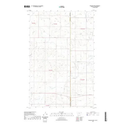
2020 Map of Red Bank Creek
USGS Topo · Published 2020About this map
Red Bank Creek and Little Muddy Creek carve through the high plains of the Montana-North Dakota state line, defining the drainage patterns of this rural borderland. The landscape is characterized by a network of sectional roads and township boundaries, including the division between Roosevelt and Williams counties. This 2020 survey reveals a remote area primarily shaped by natural topography and a grid of access roads such as Rd 1002 and Rd 1004. The lack of named settlements emphasizes the character of the northern prairie, where geographic features like the creek beds serve as the primary landmarks for local navigation and land management.
Find a feature on this map
22 named features on this map. Tap any name to fly to it.
Don’t see what you’re looking for? This feature index may not catch every label — zoom into the map to look around manually.
Map Details
Editions of this 2020 Red Bank Creek Map
This is the sole edition of this map. No revisions or reprints were ever made.
Other maps of this area

1953 · Williston
USGS Topo · 1:250,000

1954 · Wolf Point
USGS Topo · 1:250,000

1957 · Williston
USGS Topo · 1:250,000

1958 · Wolf Point
USGS Topo · 1:250,000

1968 · Trenton SW
USGS Topo · 1:24,000

1968 · Bainville SE
USGS Topo · 1:24,000

1969 · Bainville SW
USGS Topo · 1:24,000

1974 · Red Bank Creek
USGS Topo · 1:24,000

1974 · Bonetraill SW
USGS Topo · 1:24,000
1974 · Trenton NW
USGS Topo · 1:24,000