
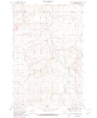
1968 Map of Red Butte NW
USGS Topo · Published 1969About this map
Otter Creek meanders through the central terrain of this North Dakota landscape, carving a drainage pattern that defines the boundary between Mercer Co and Oliver Co. The area is characterized by its agricultural and utility infrastructure during the late 1960s, marked by a prominent Pipeline stretching across the countryside and multiple water sources, including a Flowing Well and several smaller wells.
Find a feature on this map
9 named features on this map. Tap any name to fly to it.
Don’t see what you’re looking for? This feature index may not catch every label — zoom into the map to look around manually.
Map Details
Editions of this 1968 Red Butte NW Map
2 editions found
Other maps of this area

1954 · McClusky
USGS Topo · 1:250,000

1958 · McClusky
USGS Topo · 1:250,000

1968 · Red Butte
USGS Topo · 1:24,000

1968 · Beulah
USGS Topo · 1:24,000

1968 · Medicine Butte NE
USGS Topo · 1:24,000

1968 · Hazen West
USGS Topo · 1:24,000

1968 · Hazen East
USGS Topo · 1:24,000
1972 · Red Butte SW
USGS Topo · 1:24,000
1972 · Medicine Butte SE
USGS Topo · 1:24,000
1972 · Otter Creek
USGS Topo · 1:24,000