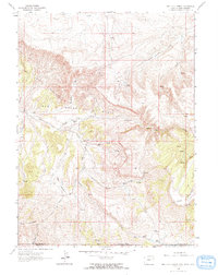
1963 Map of Red Creek Ranch
USGS Topo · Published 1966About this map
Red Creek Ranch sits at the heart of this high-desert landscape where the borders of Wyoming, Utah, and Colorado converge. Mapped in the early 1960s, the terrain is defined by the stark Red Creek Badlands and the expansive Red Creek Basin. Small-scale ranching and remote outposts like Meadow Gulch Ranch and Petes Place are connected by a network of unimproved roads and jeep trails, reflecting the isolated character of Sweetwater County during this era. High ridges such as Pine Mountain and the Tepee Mountains overlook a complex system of seasonal drainages, including Little Red Creek and Lizzie Creek. The presence of a lone Cem and family-named landmarks like Dodge Meadows provides a tangible link for genealogists tracing the early settlement patterns of this tri-state border region.
Find a feature on this map
29 named features on this map. Tap any name to fly to it.
Don’t see what you’re looking for? This feature index may not catch every label — zoom into the map to look around manually.
Map Details
Editions of this 1963 Red Creek Ranch Map
2 editions found
Other maps of this area

1885 · Ashley
USGS Topo · 1:250,000

1952 · Willow Creek Butte
USGS Topo · 1:24,000

1952 · Clay Basin
USGS Topo · 1:24,000

1954 · Vernal
USGS Topo · 1:250,000

1954 · Rock Springs
USGS Topo · 1:250,000

1958 · Vernal
USGS Topo · 1:250,000

1958 · Rock Springs
USGS Topo · 1:250,000

1960 · Vernal
USGS Topo · 1:250,000

1962 · Rock Springs
USGS Topo · 1:250,000
1963 · Maxon Ranch
USGS Topo · 1:24,000