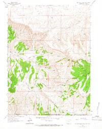
1963 Map of Red Creek Ranch
USGS Topo · Published 1966About this map
Red Creek Badlands and the expansive Red Creek Basin define this remote high-desert landscape at the intersection of the Wyoming, Utah, and Colorado borders. In the early 1960s, human activity in this corner of Sweetwater County was centered on isolated pastoral outposts like Red Creek Ranch and Meadow Gulch Ranch, connected by rugged tracks and a Jeep Trail. The terrain transitions from the dramatic erosional features of the badlands to the high elevations of Pine Mountain and the Tepee Mountains, where a solitary Radio Tower marks the summit. This survey documents a critical watershed for the region, tracing the path of Red Creek and its tributaries such as Little Red Creek and Alkali Creek, while noting essential water sources like Alkali Springs and numerous unnamed springs that supported the area's ranching operations.
Find a feature on this map
27 named features on this map. Tap any name to fly to it.
Don’t see what you’re looking for? This feature index may not catch every label — zoom into the map to look around manually.
Map Details
Editions of this 1963 Red Creek Ranch Map
2 editions found
Other maps of this area

1885 · Ashley
USGS Topo · 1:250,000

1952 · Willow Creek Butte
USGS Topo · 1:24,000

1952 · Clay Basin
USGS Topo · 1:24,000

1954 · Vernal
USGS Topo · 1:250,000

1954 · Rock Springs
USGS Topo · 1:250,000

1958 · Vernal
USGS Topo · 1:250,000

1958 · Rock Springs
USGS Topo · 1:250,000

1960 · Vernal
USGS Topo · 1:250,000

1962 · Rock Springs
USGS Topo · 1:250,000
1963 · Maxon Ranch
USGS Topo · 1:24,000