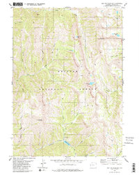
1980 Map of Red Top Mountain
USGS Topo · Published 1980About this map
Mount Fitzpatrick and the surrounding high country of the Bridger National Forest dominate this 1980 survey. The landscape is defined by a dense network of drainages and alpine basins, including the headwaters of Swift Creek, South Crow Creek, and Corral Creek. Multiple high-elevation water bodies are mapped here, such as Swift Creek Lake, Corral Creek Lake, and the Crow Creek Lakes tucked beneath the northern ridges. Transportation through these steep corridors is limited to a system of primitive routes, notably the Pack Trail and Jeep Trail networks that follow natural breaks like Mill Hollow and Gamm Hollow. To the south, Red Top Mountain rises above the confluence of Red Top Creek and Cottonwood Lake Creek, where a lone Campground marks a rare point of established human infrastructure in this backcountry environment.
Find a feature on this map
26 named features on this map. Tap any name to fly to it.
Don’t see what you’re looking for? This feature index may not catch every label — zoom into the map to look around manually.
Map Details
Editions of this 1980 Red Top Mountain Map
2 editions found
Other maps of this area

1921 · Afton
USGS Topo · 1:125,000

1955 · Preston
USGS Topo · 1:250,000

1958 · Preston
USGS Topo · 1:250,000

1962 · Preston
USGS Topo · 1:250,000
1980 · Grover
USGS Topo · 1:24,000
1980 · Smoot
USGS Topo · 1:24,000
1980 · Box Canyon Creek
USGS Topo · 1:24,000
1980 · Park Creek
USGS Topo · 1:24,000
1980 · Poison Meadows
USGS Topo · 1:24,000
1980 · Mount Wagner
USGS Topo · 1:24,000