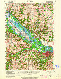
1952 Map of Red Wing
USGS Topo · Published 1964About this map
The Mississippi River valley dominates this 1952 topographic study, showing the complex aquatic landscape of islands, sloughs, and lakes just upstream from Red Wing. The intricate network of the Sturgeon Lake and North Lake area highlights the river's influence on local settlement patterns, including the Indian Reservation and the Prairie Island Indian Sch. This era captures the region at a crossroads of transport, where multiple rail lines like the Chicago Milwaukee St Paul and Pacific follow the river banks while Lock and Dam No 3 manages the waterway.
Find a feature on this map
112 named features on this map. Tap any name to fly to it.
Don’t see what you’re looking for? This feature index may not catch every label — zoom into the map to look around manually.
Map Details
Editions of this 1952 Red Wing Map
3 editions found

Other maps of this area

1940 · Maiden Rock
USGS Topo · 1:62,500

1944 · Red Wing
USGS Topo · 1:62,500

1946 · Hudson
USGS Topo · 1:62,500

1946 · River Falls
USGS Topo · 1:62,500

1949 · River Falls
USGS Topo · 1:62,500

1949 · Hudson
USGS Topo · 1:62,500

1949 · Baldwin
USGS Topo · 1:62,500

1950 · Maiden Rock
USGS Topo · 1:62,500

1951 · Prescott
USGS Topo · 1:24,000

1951 · Lake City
USGS Topo · 1:62,500