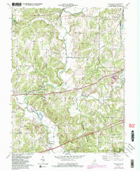
1971 Map of Reelsville
USGS Topo · Published 1987About this map
Big Walnut Creek carves a winding path through this portion of Putnam County, defining the landscape and providing the setting for a series of historic timber crossings. Local transportation history is anchored by the presence of several preserved spans, including the Houck Covered Bridge, Manhattan Covered Bridge, and Huffman Covered Bridge, which connect the rural road network across the deep creek valleys. The map illustrates the layering of eras, from the historic National Road and the early Old RR Grade to the active Conrail line passing through Reelsville. Rural community life is centered around institutions like the Reelsville Sch and several country houses of worship such as Antioch Ch and Big Walnut Ch. To the south, the terrain descends toward the northern reaches of Cagles Mill Lake and the Lieber State Rec Area, while extensive tracts of the State Prison Farm occupy the central and eastern uplands.
Find a feature on this map
40 named features on this map. Tap any name to fly to it.
Don’t see what you’re looking for? This feature index may not catch every label — zoom into the map to look around manually.
Map Details
Editions of this 1971 Reelsville Map
4 editions found
Other maps of this area

1908 · Clay City
USGS Topo · 1:48,000

1910 · Clay City
USGS Topo · 1:62,500

1950 · Brazil East
USGS Topo · 1:24,000

1951 · Clinton Falls
USGS Topo · 1:24,000

1951 · Mansfield
USGS Topo · 1:24,000

1952 · Reelsville
USGS Topo · 1:24,000

1953 · Indianapolis
USGS Topo · 1:250,000

1956 · Indianapolis
USGS Topo · 1:250,000

1956 · Cloverdale
USGS Topo · 1:24,000

1956 · Cataract
USGS Topo · 1:24,000