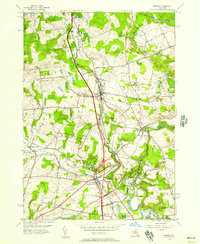
1955 Map of Remsen
USGS Topo · Published 1966About this map
Remsen and the surrounding townships in Oneida County show a landscape shaped by Welsh settlement patterns and industrial infrastructure in the mid-1950s. The influence of early immigrant communities is evident in the Welsh-named landmarks such as Capel Ucha Ch, Capel Isaf Cem, and Enlli Ch. The New York Central Railroad corridor serves as the primary spine for the region, connecting the village of Trenton Barneveld with the more industrial southern reaches.
Find a feature on this map
47 named features on this map. Tap any name to fly to it.
Don’t see what you’re looking for? This feature index may not catch every label — zoom into the map to look around manually.
Map Details
Editions of this 1955 Remsen Map
4 editions found
Other maps of this area

1895 · Oriskany
USGS Topo · 1:62,500

1897 · Remsen
USGS Topo · 1:62,500

1898 · Utica
USGS Topo · 1:62,500

1898 · Oriskany
USGS Topo · 1:62,500

1900 · Utica
USGS Topo · 1:62,500

1900 · Remsen
USGS Topo · 1:62,500

1904 · Boonville
USGS Topo · 1:62,500

1943 · Newport
USGS Topo · 1:24,000
1945 · South Trenton
USGS Topo · 1:31,680
1945 · Newport
USGS Topo · 1:31,680