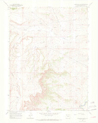
1969 Map of Reservoir Draw
USGS Topo · Published 1972About this map
The Little Snake River winds through the southeastern corner of this Moffat County landscape, a stark departure from the arid drainage patterns of Powder Wash and Reservoir Draw that dominate the terrain. Surveyed in the late 1960s, this area is defined by its industrial and hydraulic infrastructure, including a prominent Pipeline cutting across the northern sections and several Drill Hole sites and a Drill Hole Well. The presence of Reservoir Spring in the southwest suggests a vital water source in an otherwise dry network of draws like Horse Draw. Situated just south of the Wyoming state line, the map captures a remote section of the Colorado borderlands where mineral exploration and water management intersect.
Find a feature on this map
9 named features on this map. Tap any name to fly to it.
Don’t see what you’re looking for? This feature index may not catch every label — zoom into the map to look around manually.
Map Details
Editions of this 1969 Reservoir Draw Map
3 editions found
Other maps of this area

1954 · Vernal
USGS Topo · 1:250,000

1954 · Rock Springs
USGS Topo · 1:250,000

1958 · Vernal
USGS Topo · 1:250,000

1958 · Rock Springs
USGS Topo · 1:250,000

1960 · Vernal
USGS Topo · 1:250,000

1962 · Rock Springs
USGS Topo · 1:250,000

1969 · Reservoir Draw
USGS Topo · 1:24,000
1969 · The Nipple SE
USGS Topo · 1:24,000

1969 · The Nipple
USGS Topo · 1:24,000
1969 · The Nipple NE
USGS Topo · 1:24,000