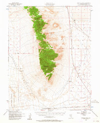
1952 Map of Reveille Peak
USGS Topo · Published 1964About this map
The central Reveille Range dominates this mid-century topographic survey, serving as the high-ground divide between the expansive Reveille Valley to the west and Railroad Valley to the east. At its highest point stands Reveille Peak, surrounded by a landscape defined more by sparse water resources and isolated outposts than by permanent settlements. The southern portion of the map is marked by the boundary of the Las Vegas Bombing and Gunnery Range, illustrating the increasing military footprint in the Nevada desert during the early Cold War.
Find a feature on this map
21 named features on this map. Tap any name to fly to it.
Don’t see what you’re looking for? This feature index may not catch every label — zoom into the map to look around manually.
Map Details
Editions of this 1952 Reveille Peak Map
3 editions found
Other maps of this area

1908 · Kawich
USGS Topo · 1:250,000

1942 · Reveille Peak
USGS Topo · 1:125,000

1942 · Penoyer Valley
USGS Topo · 1:125,000

1952 · Kawich Peak
USGS Topo · 1:62,500

1952 · Quartzite Mtn
USGS Topo · 1:62,500

1952 · White Blotch Springs
USGS Topo · 1:62,500

1952 · Reveille Peak
USGS Topo · 1:62,500

1952 · Belted Peak
USGS Topo · 1:62,500

1954 · Caliente
USGS Topo · 1:250,000

1954 · Goldfield
USGS Topo · 1:250,000