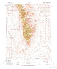
1952 Map of Reveille Peak
USGS Topo · Published 1984About this map
Reveille Range dominates this central Nevada landscape, rising sharply between the wide basins of Reveille Valley and Railroad Valley. Surveyed in the early 1950s, the map provides a look at the remote desert infrastructure of Nye County, including the Mt Diablo Base Line and isolated water sources like Freds Well and a Reservoir. The southern portion of the sheet is marked by the presence of the Las Vegas Bombing and Gunnery Range, highlighting the era's expanding military footprint in the Great Basin. Human presence is sparse, centered on the Cedar Pipeline Ranch at the mountain base and a Landing Field (Aband) on the valley floor. Features such as Reveille Peak and the distinctive Fang Ridge provide vertical relief in an area primarily defined by drainage patterns and intermittent springs.
Find a feature on this map
13 named features on this map. Tap any name to fly to it.
Don’t see what you’re looking for? This feature index may not catch every label — zoom into the map to look around manually.
Map Details
Editions of this 1952 Reveille Peak Map
3 editions found
Other maps of this area

1908 · Kawich
USGS Topo · 1:250,000

1942 · Reveille Peak
USGS Topo · 1:125,000

1942 · Penoyer Valley
USGS Topo · 1:125,000

1952 · Kawich Peak
USGS Topo · 1:62,500

1952 · Quartzite Mtn
USGS Topo · 1:62,500

1952 · White Blotch Springs
USGS Topo · 1:62,500

1952 · Reveille Peak
USGS Topo · 1:62,500

1952 · Belted Peak
USGS Topo · 1:62,500

1954 · Caliente
USGS Topo · 1:250,000

1954 · Goldfield
USGS Topo · 1:250,000