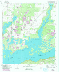
1955 Map of Reynoldsville
USGS Topo · Published 1994About this map
Lake Seminole dominates the landscape of southwest Georgia in this mid-century survey, where the convergence of the Flint River and Spring Creek creates a vast network of inlets and islands. Along the northern shores, the settlement of Reynoldsville stands near several family and community landmarks, including Cloud Cem and Calvary Ch. The map provides a detailed look at the local social geography, from the Spring Creek Courthouse and Spring Creek Ch to the recreational and landing areas such as Seminola State Park and Henry Cummings Landing. Further south, the presence of the Sealy Plantation reflects the region's agricultural heritage, while features like Fishpond Drain and Harvel Pond illustrate the intricate hydrology of the Seminole and Decatur county line area. This document preserves the character of the riverfront before modern development further altered the shoreline.
Find a feature on this map
23 named features on this map. Tap any name to fly to it.
Don’t see what you’re looking for? This feature index may not catch every label — zoom into the map to look around manually.
Map Details
Editions of this 1955 Reynoldsville Map
4 editions found
Other maps of this area

1954 · Steam Mill
USGS Topo · 1:24,000

1954 · Sneads
USGS Topo · 1:24,000

1954 · Desser
USGS Topo · 1:24,000

1954 · Tallahassee
USGS Topo · 1:250,000

1955 · Fairchild
USGS Topo · 1:24,000

1955 · Reynoldsville
USGS Topo · 1:24,000

1955 · Chattahoochee
USGS Topo · 1:24,000

1955 · Bainbridge
USGS Topo · 1:62,500

1955 · Mt Pleasant
USGS Topo · 1:24,000

1959 · Tallahassee
USGS Topo · 1:250,000