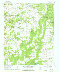
1970 Map of Rhea
USGS Topo · Published 1972About this map
Ozark National Forest covers the eastern ridges of this 1970 landscape, where Weddington Mountain and Marrs Hill rise above the agricultural valleys of western Washington County. The settlement patterns of the era are clearly defined by localized community hubs like Weddington, Rheas Mill, and Norwood, each serving as a focal point for the surrounding rural homesteads. The terrain is deeply carved by water sources such as Moores Creek, Spring Creek, and Cincinnati Creek, while landmarks like the Weddington Lookout Tower and Roundtop provide orienting heights over the undulating topography.
Find a feature on this map
29 named features on this map. Tap any name to fly to it.
Don’t see what you’re looking for? This feature index may not catch every label — zoom into the map to look around manually.
Map Details
Editions of this 1970 Rhea Map
3 editions found
Other maps of this area

1898 · Tahlequah
USGS Topo · 1:125,000

1898 · Winslow
USGS Topo · 1:125,000

1899 · Fayetteville
USGS Topo · 1:125,000

1899 · Siloam Springs
USGS Topo · 1:125,000

1901 · Winslow
USGS Topo · 1:125,000

1901 · Fayetteville
USGS Topo · 1:125,000

1901 · Tahlequah
USGS Topo · 1:125,000

1903 · Siloam Springs
USGS Topo · 1:125,000

1904 · Siloam Springs
USGS Topo · 1:125,000

1904 · Fayetteville
USGS Topo · 1:125,000