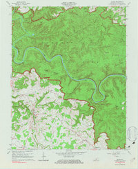
1965 Map of Rhoda
USGS Topo · Published 1983About this map
Mammoth Cave National Park dominates the northern and eastern portions of this Edmonson County landscape, defined by the winding course of the Green River. The river forms dramatic loops at Turnhole Bend and passes several river-formed features including Crump Island and Stice Island. The park boundary creates a distinct transition between the heavily wooded ridges of the preserve and the settled agricultural lands to the southwest, where the community of Rhoda and the village of Chalybeate are located.
Find a feature on this map
66 named features on this map. Tap any name to fly to it.
Don’t see what you’re looking for? This feature index may not catch every label — zoom into the map to look around manually.
Map Details
Editions of this 1965 Rhoda Map
2 editions found
Other maps of this area

1922 · Leitchfield
USGS Topo · 1:48,000

1922 · Brownsville
USGS Topo · 1:62,500

1922 · Mammoth Cave
USGS Topo · 1:62,500

1923 · Mammoth Cave
USGS Topo · 1:62,500

1923 · Brownsville
USGS Topo · 1:62,500

1925 · Cub Run
USGS Topo · 1:62,500

1925 · Leitchfield
USGS Topo · 1:62,500

1953 · Bee Spring
USGS Topo · 1:24,000

1954 · Evansville
USGS Topo · 1:250,000
1954 · Dickeys Mills
USGS Topo · 1:24,000