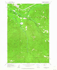
1962 Map of Rhododendron
USGS Topo · Published 1964About this map
Mt Hood National Forest dominates this topographic study, where the Sandy River and Salmon River converge amidst a dense network of mountain peaks and recreational outposts. The early 1960s landscape is defined by its transition from roadside settlements like Wemme and Rhododendron to the high elevations of Hunchback Mountain and Zigzag Mountain. Local life and forest management are anchored at the Welches Sch, the Zigzag Ranger Station, and the Salmon River Guard Station. For genealogists and local historians, the map preserves the exact locations of mid-century community landmarks, including the Mt Hood Golf Course and numerous campgrounds such as Pioneer Tollgate Campground and Rolling Riffle Campground, alongside historic routes like the Pioneer Bridle Trail.
Find a feature on this map
55 named features on this map. Tap any name to fly to it.
Don’t see what you’re looking for? This feature index may not catch every label — zoom into the map to look around manually.
Map Details
Editions of this 1962 Rhododendron Map
3 editions found
Other maps of this area

1916 · Estacada
USGS Topo · 1:125,000

1924 · Mount Hood
USGS Topo · 1:125,000

1927 · Mount Hood
USGS Topo · 1:125,000

1948 · Vancouver
USGS Topo · 1:250,000

1950 · Vancouver
USGS Topo · 1:250,000

1950 · Vancouver
USGS Topo · 1:250,000

1953 · The Dalles
USGS Topo · 1:250,000

1955 · Cherryville
USGS Topo · 1:62,500

1956 · The Dalles
USGS Topo · 1:250,000

1956 · Fish Creek Mtn
USGS Topo · 1:62,500