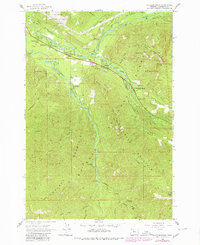
1962 Map of Rhododendron
USGS Topo · Published 1980About this map
Mt. Hood National Forest provides the setting for this 1962 survey of the upper Sandy River valley, where the small settlements of Rhododendron, Zigzag, and Welches serve as gateways to the high Cascades. The map details a landscape transitioning from the valley floor at Wemme and Wildwood to the high ridges of Hunchback Mountain and Salmon River Mountain. The presence of the Mt Hood Golf Course and Camp Arrah Wanna alongside the Welches Sch reflects the area's development as a recreational and residential hub during the mid-20th century.
Find a feature on this map
60 named features on this map. Tap any name to fly to it.
Don’t see what you’re looking for? This feature index may not catch every label — zoom into the map to look around manually.
Map Details
Editions of this 1962 Rhododendron Map
3 editions found
Other maps of this area

1916 · Estacada
USGS Topo · 1:125,000

1924 · Mount Hood
USGS Topo · 1:125,000

1927 · Mount Hood
USGS Topo · 1:125,000

1948 · Vancouver
USGS Topo · 1:250,000

1950 · Vancouver
USGS Topo · 1:250,000

1950 · Vancouver
USGS Topo · 1:250,000

1953 · The Dalles
USGS Topo · 1:250,000

1955 · Cherryville
USGS Topo · 1:62,500

1956 · The Dalles
USGS Topo · 1:250,000

1956 · Fish Creek Mtn
USGS Topo · 1:62,500