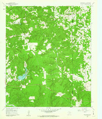
1960 Map of Rhonesboro
USGS Topo · Published 1962About this map
Rhonesboro and the surrounding piney woods of East Texas are captured here during the early 1960s, a landscape defined by its intricate drainage network and rural outposts. The settlement of Perryville sits near the headwaters of Webster Branch, while the community of Ogburn anchors the western portion of the sheet. For those researching the era's local infrastructure, the Old Railroad Grade cutting through the southern hills and the numerous pipelines traversing the terrain reveal the region's industrial and transportation history. Local landmarks like Camp Deer Run and the Little Hope Ch suggest a well-established community life amidst the creeks and branches. Notable water features such as Gunstream Lakes and the curiously named Homebrew Branch highlight the topographic variety of the Wood and Upshur county line.
Find a feature on this map
32 named features on this map. Tap any name to fly to it.
Don’t see what you’re looking for? This feature index may not catch every label — zoom into the map to look around manually.
Map Details
Editions of this 1960 Rhonesboro Map
4 editions found
Other maps of this area

1956 · Tyler
USGS Topo · 1:250,000

1960 · Shady Grove
USGS Topo · 1:24,000

1960 · Pritchett
USGS Topo · 1:24,000

1960 · Hainesville
USGS Topo · 1:24,000

1960 · Winnsboro
USGS Topo · 1:24,000

1960 · Cartwright
USGS Topo · 1:24,000

1960 · Thomas
USGS Topo · 1:24,000

1960 · Newsome
USGS Topo · 1:24,000

1960 · Leesburg
USGS Topo · 1:24,000

1960 · Rhonesboro
USGS Topo · 1:24,000