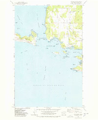
1977 Map of Richardson
USGS Topo · Published 1978About this map
The maritime convergence of the San Juan Channel and the Strait of Juan de Fuca dominates this late-1970s coastal study. The southern tip of San Juan Island is anchored by the prominent Mt Finlayson and Cattle Point, where the San Juan Island National Historical Park preserves the site of former military encampments. Across the Middle Channel, the southwestern shoreline of Lopez Island reveals a landscape of deep inlets and rocky outcrops, including the sheltered Mackaye Harbor and the remote Iceberg Point. The presence of the Lopez Island Airport and a Golf Course indicates the area's mid-century transition toward recreation and light aviation, while the small settlement of Richardson remains a focal point on the waterfront. Extensive hydrographic details like the Salmon Bank and McArthur Bank reflect the critical navigational nature of these waters during the era.
Find a feature on this map
56 named features on this map. Tap any name to fly to it.
Don’t see what you’re looking for? This feature index may not catch every label — zoom into the map to look around manually.
Map Details
Editions of this 1977 Richardson Map
2 editions found
Other maps of this area

1943 · Richardson
USGS Topo · 1:62,500

1943 · Orcas Island
USGS Topo · 1:62,500

1954 · Friday Harbor
USGS Topo · 1:24,000

1954 · False Bay
USGS Topo · 1:24,000

1957 · Richardson
USGS Topo · 1:62,500

1957 · Orcas Island
USGS Topo · 1:62,500

1957 · Victoria
USGS Topo · 1:250,000
1973 · Lopez Pass
USGS Topo · 1:24,000

1973 · Shaw Island
USGS Topo · 1:24,000
1973 · Blakely Island
USGS Topo · 1:24,000