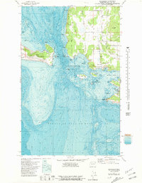
1977 Map of Richardson
USGS Topo · Published 1981About this map
The southern shoreline of Lopez Island and the southeastern tip of San Juan Island meet across the deep waters of the San Juan Channel and Middle Channel. At the heart of the southern coast, the settlement of Richardson serves as a focal point near Davis Bay and Mackaye Harbor, areas defined by a complex network of smaller islands such as Charles Island and Long Island. This late 1970s bathymetric-topographic survey highlights the transition from the upland heights of Lopez Hill down to the dramatic maritime hazards of Shark Reef and Iceberg Point. On San Juan Island, the landscape is preserved within the San Juan National Historical Park, where Mt Finlayson rises above the dunes of Cattle Point. The presence of the Lopez Island Airport and the San Juan Islands Nat Wildlife Refuge illustrates the modern balance of utility and conservation in the archipelago.
Find a feature on this map
46 named features on this map. Tap any name to fly to it.
Don’t see what you’re looking for? This feature index may not catch every label — zoom into the map to look around manually.
Map Details
Editions of this 1977 Richardson Map
2 editions found
Other maps of this area

1943 · Richardson
USGS Topo · 1:62,500

1943 · Orcas Island
USGS Topo · 1:62,500

1954 · Friday Harbor
USGS Topo · 1:24,000

1954 · False Bay
USGS Topo · 1:24,000

1957 · Richardson
USGS Topo · 1:62,500

1957 · Orcas Island
USGS Topo · 1:62,500

1957 · Victoria
USGS Topo · 1:250,000
1973 · Lopez Pass
USGS Topo · 1:24,000

1973 · Shaw Island
USGS Topo · 1:24,000
1973 · Blakely Island
USGS Topo · 1:24,000