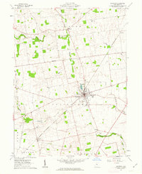
1961 Map of Richwood
USGS Topo · Published 1963About this map
Richwood serves as the central hub for this corner of Union County, centered around its local Fairground and the waters of Richwood Lake. The surrounding landscape is defined by its deep historical boundaries, most notably the Greenville Treaty Line which bisects the terrain, and the administrative divisions of Jackson, Claiborne, and Leesburg townships. The Erie-Lackawanna railroad cuts a diagonal path through the countryside, connecting the village to outlying points like Essex and Woodland. Genealogists will find a significant distribution of family and community burial sites, including Price Cem, Chenney Cem, and Stony Point Cem. Waterways such as Rush Creek, Fulton Creek, and Ottawa Creek provide the primary drainage for this agricultural region, while local industry is represented by scattered Gravel Pits north of the village.
Find a feature on this map
26 named features on this map. Tap any name to fly to it.
Don’t see what you’re looking for? This feature index may not catch every label — zoom into the map to look around manually.
Map Details
Editions of this 1961 Richwood Map
This is the sole edition of this map. No revisions or reprints were ever made.
Other maps of this area

1903 · Marion
USGS Topo · 1:62,500

1905 · Marion
USGS Topo · 1:62,500

1913 · Richwood
USGS Topo · 1:62,500

1915 · Richwood
USGS Topo · 1:62,500

1915 · La Rue
USGS Topo · 1:62,500

1924 · Delaware
USGS Topo · 1:62,500

1925 · Delaware
USGS Topo · 1:62,500

1944 · Richwood
USGS Topo · 1:62,500

1944 · Delaware
USGS Topo · 1:62,500

1950 · Marion
USGS Topo · 1:250,000
Featured Places
- Richwood, Claibourne Township
- Essex, Jackson Township
- Woodland, Jackson Township
- Claibourne Township, OH
- York Township, OH