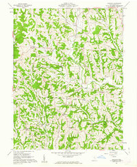
1961 Map of Ringgold
USGS Topo · Published 1963About this map
The Wolf Creek Wildlife Area and Wayne National Forest dominate this section of Morgan County, where the landscape is defined by the sharp dendritic drainage of West Branch Wolf Creek and Federal Creek. Small rural communities like Ringgold and Rosseau anchor the uplands, while the land division reflects the complex history of the Ohio Company Purchase. The map reveals an active extraction landscape with numerous Gas Wells interspersed among traditional rural landmarks.
Find a feature on this map
37 named features on this map. Tap any name to fly to it.
Don’t see what you’re looking for? This feature index may not catch every label — zoom into the map to look around manually.
Map Details
Editions of this 1961 Ringgold Map
4 editions found
Other maps of this area

1903 · Athens
USGS Topo · 1:62,500

1904 · Chesterhill
USGS Topo · 1:62,500

1905 · Athens
USGS Topo · 1:62,500

1906 · Chesterhill
USGS Topo · 1:62,500

1910 · Mc Connelsville
USGS Topo · 1:62,500

1911 · New Lexington
USGS Topo · 1:62,500

1947 · Columbus
USGS Topo · 1:250,000

1949 · Clarksburg
USGS Topo · 1:250,000

1956 · Clarksburg
USGS Topo · 1:250,000

1960 · Amesville
USGS Topo · 1:24,000