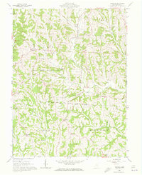
1961 Map of Ringgold
USGS Topo · Published 1973About this map
Wolf Creek Wildlife Area and a portion of the Wayne National Forest dominate this landscape in Morgan County, where the topography is defined by the intricate branching of West Branch Wolf Creek and Federal Creek. In the early 1960s, this area was a landscape in transition, where old agricultural land lines from the Congress Lands East of Scioto River and the North Boundary Ohio Company Purchase meet modern conservation efforts. Small rural hubs like Ringgold and Mountville anchor the map, while the presence of numerous gas wells scattered across the hillsides of Union and Homer townships points to the region's underlying industrial utility. For the family researcher, the map preserves the exact locations of several country institutions, including the Union-Homer Sch, Pisgah Ch, and many hilltop burying grounds like the Pleasant Hill Ch Cem.
Find a feature on this map
40 named features on this map. Tap any name to fly to it.
Don’t see what you’re looking for? This feature index may not catch every label — zoom into the map to look around manually.
Map Details
Editions of this 1961 Ringgold Map
4 editions found
Other maps of this area

1903 · Athens
USGS Topo · 1:62,500

1904 · Chesterhill
USGS Topo · 1:62,500

1905 · Athens
USGS Topo · 1:62,500

1906 · Chesterhill
USGS Topo · 1:62,500

1910 · Mc Connelsville
USGS Topo · 1:62,500

1911 · New Lexington
USGS Topo · 1:62,500

1947 · Columbus
USGS Topo · 1:250,000

1949 · Clarksburg
USGS Topo · 1:250,000

1956 · Clarksburg
USGS Topo · 1:250,000

1960 · Amesville
USGS Topo · 1:24,000