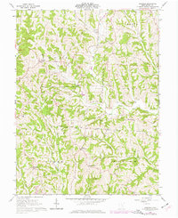
1961 Map of Ringgold
USGS Topo · Published 1977About this map
Wayne National Forest and the Wolf Creek Wildlife Area dominate this section of Morgan County, where the topography is defined by the winding drainages of West Branch Wolf Creek and Sharps Fork Federal Creek. This 1961 field-checked survey reveals a landscape where the natural gas industry left a significant footprint, noted by numerous Gas Wells scattered across the ridges. Small rural communities like Ringgold and Rosseau are connected by a network of winding roads, many following the property lines of the Ohio Company Purchase and Congress Lands North of Old Seven Ranges. These early land subdivisions remain visible in the irregular township boundaries of Union, Penn, Homer, and Marion. Local genealogy is well-documented through landmarks like Union-Homer Sch and various hilltop church sites including Mt Olive Ch Cem.
Find a feature on this map
45 named features on this map. Tap any name to fly to it.
Don’t see what you’re looking for? This feature index may not catch every label — zoom into the map to look around manually.
Map Details
Editions of this 1961 Ringgold Map
4 editions found
Other maps of this area

1903 · Athens
USGS Topo · 1:62,500

1904 · Chesterhill
USGS Topo · 1:62,500

1905 · Athens
USGS Topo · 1:62,500

1906 · Chesterhill
USGS Topo · 1:62,500

1910 · Mc Connelsville
USGS Topo · 1:62,500

1911 · New Lexington
USGS Topo · 1:62,500

1947 · Columbus
USGS Topo · 1:250,000

1949 · Clarksburg
USGS Topo · 1:250,000

1956 · Clarksburg
USGS Topo · 1:250,000

1960 · Amesville
USGS Topo · 1:24,000