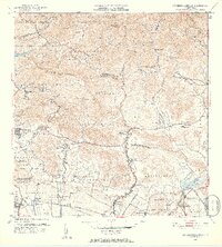
1952 Map of Rio Descalabrado
USGS Topo · Published 1953About this map
Campo Losey and its adjacent Aeropuerto anchor the southwestern corner of this coastal landscape, reflecting mid-century military infrastructure along the southern shores of Puerto Rico. The terrain transitions from the Caribbean coastline through agricultural barrios like Cintrona and Boca Velazquez toward the northern peaks of Cerro de las Cuevas and Cerro Petronila. This 1952 revision provides a look at the island's traditional plantation economy through numerous named estates, including Hacienda Miranda, Hacienda Amelia, and Hacienda Ursula. Water management is central to the local geography, visible in the Canal system feeding off the Rio Descalabrado and the presence of Lago Coamo to the east. Several rural schools, such as the Escuela Segunda Unidad de Santa Catalina, serve established settlements like Poblado Guayabal and Los Llanos along Carretera 14.
Find a feature on this map
69 named features on this map. Tap any name to fly to it.
Don’t see what you’re looking for? This feature index may not catch every label — zoom into the map to look around manually.
Map Details
Editions of this 1952 Rio Descalabrado Map
2 editions found
Other maps of this area

1944 · Santa Isabel
USGS Topo · 1:30,000

1945 · Playa De Ponce
USGS Topo · 1:30,000

1945 · Ponce
USGS Topo · 1:30,000

1945 · Rio Descalabrado
USGS Topo · 1:30,000

1945 · Salinas
USGS Topo · 1:30,000

1946 · Coamo
USGS Topo · 1:30,000

1946 · Barranquitas
USGS Topo · 1:30,000

1946 · Jayuya
USGS Topo · 1:30,000

1946 · Orocovis
USGS Topo · 1:30,000

1947 · Ponce NE
USGS Topo · 1:10,000
Featured Places
- Sector Caribe, Coamo
- Sector Verdún, Coamo
- Valle Paraíso, Coamo
- Comunidad Johnny Tosco, Coamo
- Quintas del Llano, Coamo