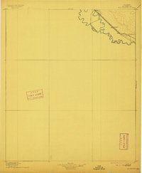
1896 Map of Rio Grande
USGS Topo · Published 1911About this map
The Rio Grande defines the international boundary between United States Mexico and Texas Chihuahua in this late nineteenth-century survey, which documents the arid valley floor just before significant irrigation projects transformed the landscape. The geography is characterized by the meandering river and the critical path of the Southern Pacific R. R. (Galveston Harrisburg and San Antonio Div.), which served as the primary artery for trade and movement through El Paso County. Surveyed originally in 1891 and updated with data from the Reclamation Service, this sheet identifies early railroad-oriented settlements like Fabens, Tornillo, and Rio Grande. Genealogists and historians can use several precise elevation benchmarks, such as BM 3607 and BM 3570, to orient family property or historical landmarks within the sparsely populated desert terrain along the rail line.
Find a feature on this map
10 named features on this map. Tap any name to fly to it.
Don’t see what you’re looking for? This feature index may not catch every label — zoom into the map to look around manually.
Map Details
Editions of this 1896 Rio Grande Map
4 editions found
Other maps of this area

1894 · Fort Hancock
USGS Topo · 1:125,000

1896 · El Paso
USGS Topo · 1:125,000

1896 · Rio Grande
USGS Topo · 1:125,000

1903 · Cerro Alto
USGS Topo · 1:125,000

1908 · El Paso
USGS Topo · 1:125,000

1939 · Ysleta
USGS Topo · 1:62,500

1941 · Clint
USGS Topo · 1:62,500

1941 · Ysleta
USGS Topo · 1:62,500

1941 · Tornillo
USGS Topo · 1:62,500

1942 · Borrego
USGS Topo · 1:62,500