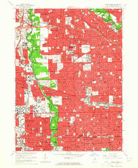
1963 Map of River Forest
USGS Topo · Published 1964About this map
The Des Plaines River corridor serves as the primary green artery through this densely developed mid-century landscape, separating the suburbs of Melrose Park and River Grove from the northwestern edge of Chicago. Extensive forest preserves and parklands like Camp Fort Dearborn and Norwood Park contrast with the grid-based residential expansion and the massive institutional presence of the Chicago State Hospital. Significant infrastructure projects of the era are prominent, including the Tri-State Tollway and the Kennedy Expressway, which facilitate movement through the township of Leyden.
Find a feature on this map
139 named features on this map. Tap any name to fly to it.
Don’t see what you’re looking for? This feature index may not catch every label — zoom into the map to look around manually.
Map Details
Editions of this 1963 River Forest Map
4 editions found
Other maps of this area

1889 · Chicago
USGS Topo · 1:62,500

1891 · Chicago
USGS Topo · 1:62,500

1891 · Riverside
USGS Topo · 1:62,500

1893 · Riverside
USGS Topo · 1:62,500

1899 · Evanston
USGS Topo · 1:62,500

1900 · Chicago
USGS Topo · 1:62,500

1900 · Riverside
USGS Topo · 1:62,500

1900 · Highwood
USGS Topo · 1:62,500

1901 · Riverside
USGS Topo · 1:62,500

1901 · Chicago
USGS Topo · 1:62,500