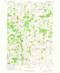
1965 Map of Riverdale
USGS Topo · Published 1967About this map
Riverdale sits at the junction of the Chesapeake and Ohio railroad and the Pine River, serving as a central hub for this portion of Gratiot County in the mid-1960s. The landscape is a mosaic of agricultural fields and water bodies, including Half Moon Lake and La Strange Lake, punctuated by numerous Gravel Pits that suggest a local industry focused on aggregate extraction. The presence of aviation facilities like Lippert Airport and the Strahan Landing Strip indicates a rural area well-connected by both rail and air.
Find a feature on this map
65 named features on this map. Tap any name to fly to it.
Don’t see what you’re looking for? This feature index may not catch every label — zoom into the map to look around manually.
Map Details
Editions of this 1965 Riverdale Map
This is the sole edition of this map. No revisions or reprints were ever made.
Other maps of this area

1916 · Mount Pleasant
USGS Topo · 1:62,500

1919 · Mount Pleasant
USGS Topo · 1:62,500

1930 · Shepherd
USGS Topo · 1:48,000

1935 · Alma
USGS Topo · 1:62,500

1936 · Shepherd
USGS Topo · 1:62,500

1938 · Alma
USGS Topo · 1:62,500

1943 · Mount Pleasant
USGS Topo · 1:62,500

1954 · Midland
USGS Topo · 1:250,000

1958 · Midland
USGS Topo · 1:250,000

1959 · Midland
USGS Topo · 1:250,000