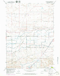
1957 Map of Riverton NE
USGS Topo · Published 1979About this map
Missouri Valley serves as a focal point for this survey, showcasing an intricate network of irrigation and land management in central Wyoming. The landscape is defined by the heavy infrastructure of the Riverton Reclamation Withdrawal Area, where numerous Ditch and Siphon features indicate a highly engineered approach to desert agriculture. This transformation is centered along Fivemile Creek, which winds through the valley between the Withdrawal Area Boundary and the northern reaches of the Wind River Indian Reservation.
Find a feature on this map
20 named features on this map. Tap any name to fly to it.
Don’t see what you’re looking for? This feature index may not catch every label — zoom into the map to look around manually.
Map Details
Editions of this 1957 Riverton NE Map
4 editions found
Other maps of this area

1950 · Riverton East
USGS Topo · 1:24,000

1950 · Mexican Pass SW
USGS Topo · 1:24,000

1950 · Bonneville SW
USGS Topo · 1:24,000

1951 · Mexican Pass SE
USGS Topo · 1:24,000

1951 · Indian Butte
USGS Topo · 1:24,000

1951 · Hidden Valley
USGS Topo · 1:24,000

1951 · Riverton West
USGS Topo · 1:24,000

1952 · Riverton NE
USGS Topo · 1:24,000

1952 · Lost Wells Butte
USGS Topo · 1:24,000

1955 · Thermopolis
USGS Topo · 1:250,000