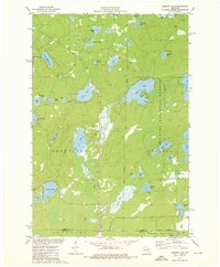
1973 Map of Roberts Lake
USGS Topo · Published 1976About this map
Roberts Lake and the dense water systems of the Nicolet National Forest define this landscape during the early 1970s. The region is characterized by a high concentration of glacial kettle lakes, ranging from larger bodies like Lily Lake and Arbutus Lake to smaller, sequestered pools such as Jungle Lake, Horseshoe Lake, and Popple Lake. Human settlement is sparse and centered on small junctions like Woodlawn and Freedom Corners, while the Soo Line railroad cuts a straight path through the northwestern timberlands, marking the industrial backbone of the local timber economy. The southern portion of the quadrangle reveals the wetlands of the Bog Brook State Wildlife Area, where the Lily River meanders toward the settlement of Choate near the Forest and Langlade County line.
Find a feature on this map
50 named features on this map. Tap any name to fly to it.
Don’t see what you’re looking for? This feature index may not catch every label — zoom into the map to look around manually.
Map Details
Editions of this 1973 Roberts Lake Map
2 editions found
Other maps of this area

1939 · Crandon
USGS Topo · 1:48,000

1939 · Laona
USGS Topo · 1:48,000

1941 · Crandon
USGS Topo · 1:48,000

1942 · Wabeno
USGS Topo · 1:48,000

1942 · Pearson
USGS Topo · 1:48,000

1946 · Laona
USGS Topo · 1:48,000

1947 · Crandon
USGS Topo · 1:48,000

1950 · Wabeno
USGS Topo · 1:48,000

1950 · Lily
USGS Topo · 1:48,000

1951 · Wabeno
USGS Topo · 1:48,000