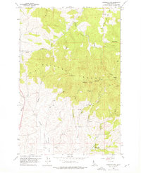
1960 Map of Robinson Lake
USGS Topo · Published 1976About this map
The Palouse Range dominates this landscape, rising to prominent heights at East Twin and West Twin. This 1960 field-checked survey reveals the mid-century infrastructure supporting the region, including Radio Relay Stations situated along the high ridges and a Gaging Sta monitoring the South Fork Palouse River. The drainage patterns are intricate, with Flannigan Creek and Paradise Creek carving through the terrain, while the White Cross Mine serves as a reminder of local mineral exploration. In the south, Robinson Lake is established behind a specified spillway, marking a point of water management and local geography. The map also documents numerous benchmarks and a Rocky Point Lookout, highlighting the area's importance for observation and surveying during the late 1950s.
Find a feature on this map
41 named features on this map. Tap any name to fly to it.
Don’t see what you’re looking for? This feature index may not catch every label — zoom into the map to look around manually.
Map Details
Editions of this 1960 Robinson Lake Map
3 editions found
Other maps of this area

1910 · Pullman
USGS Topo · 1:125,000

1955 · Pullman
USGS Topo · 1:250,000

1958 · Pullman
USGS Topo · 1:250,000

1960 · Troy
USGS Topo · 1:24,000

1960 · Robinson Lake
USGS Topo · 1:24,000

1960 · Moscow Mtn
USGS Topo · 1:24,000

1960 · Moscow East
USGS Topo · 1:24,000

1960 · Potlatch
USGS Topo · 1:62,500

1961 · Moscow
USGS Topo · 1:62,500

1964 · Viola
USGS Topo · 1:24,000