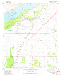
1981 Map of Robinsonville
USGS Topo · Published 1982About this map
Robinsonville and the agricultural lands of the Mississippi Delta are captured here in the early 1980s, defined by the winding course of the Mississippi River and the remnants of its former channels. The landscape is a network of bayous and brakes, including Hollywood Brake and Buck Island Bayou, illustrating the complex drainage patterns of this floodplain. Historically significant for genealogists, the map identifies numerous rural congregations and resting places, such as St Peters Ch and its accompanying St Peters Cem, along with Mt Olive Cem and Rainey Cem. The Illinois Central Gulf railroad cuts a straight line through the territory, passing through settlements like Bowdre and Penton. This rail corridor, running parallel to the river's path, highlights the transportation infrastructure that once supported the local cotton economy and small-town commerce along Commerce Road.
Find a feature on this map
43 named features on this map. Tap any name to fly to it.
Don’t see what you’re looking for? This feature index may not catch every label — zoom into the map to look around manually.
Map Details
Editions of this 1981 Robinsonville Map
2 editions found
Other maps of this area

1908 · Hollywood
USGS Topo · 1:24,000

1908 · Lake Cormorant
USGS Topo · 1:24,000

1912 · Lake Cormorant
USGS Topo · 1:31,680

1913 · Hollywood
USGS Topo · 1:31,680

1931 · Horseshoe Lake
USGS Topo · 1:62,500

1932 · Horn Lake
USGS Topo · 1:48,000

1932 · Crenshaw
USGS Topo · 1:62,500

1935 · Crenshaw
USGS Topo · 1:62,500

1935 · Horn Lake
USGS Topo · 1:62,500

1939 · Clayton
USGS Topo · 1:62,500