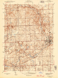
1945 Map of Rochester
USGS Topo · Published 1945About this map
The settlement of Rochester and its surroundings in Oakland County are captured here during the mid-1940s, a period when the landscape was a mix of small village centers and rural school districts. The community is linked by significant transportation corridors, including the Michigan Central and Grand Trunk Western railroads, which parallel the course of Paint Creek and the Clinton River. In the western reaches of the quadrangle, the terrain rises toward Bald Mtn, where the Bald Mtn Golf Club and various localized ditches like Dutton Ditch define the land use. This survey is particularly valuable for its density of rural educational landmarks, identifying nearly a dozen neighborhood schools such as Bigler Sch, Five Points Sch, and Hubble Sch. These sites, along with the Oakland Cem, provide specific geographic anchors for researchers tracing family property and local development before the post-war suburban expansion.
Find a feature on this map
62 named features on this map. Tap any name to fly to it.
Don’t see what you’re looking for? This feature index may not catch every label — zoom into the map to look around manually.
Map Details
Editions of this 1945 Rochester Map
2 editions found
Other maps of this area

1907 · Pontiac
USGS Topo · 1:62,500

1908 · Rochester
USGS Topo · 1:62,500

1936 · Warren
USGS Topo · 1:31,680

1936 · Birmingham
USGS Topo · 1:31,680

1936 · Rochester
USGS Topo · 1:31,680

1936 · Washington
USGS Topo · 1:31,680

1936 · Pontiac South
USGS Topo · 1:31,680

1936 · Pontiac North
USGS Topo · 1:31,680

1943 · Pontiac South
USGS Topo · 1:24,000

1943 · Pontiac North
USGS Topo · 1:24,000
Featured Places
- Rochester Hills, MI
- Pontiac, MI
- Orion Charter Township, MI
- Auburn Hills, MI
- Oakland Charter Township, MI