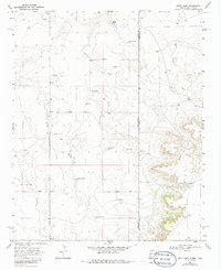
1968 Map of Rock Camp
USGS Topo · Published 1986About this map
Windmills and ranching infrastructure define this arid landscape along the border of New Mexico and Texas in the late 1960s. The region is marked by a scattered network of water sources essential for cattle, including Brown Windmill, Peters Windmill, Willson Windmill, and the Love Windmill. Large landholdings like the Bowe Ranch and Parcell Ranch occupy the high plains of Quay County, where the terrain is carved by seasonal drainages such as Arroyo del Puerto and Arroyo Trujillo.
Find a feature on this map
24 named features on this map. Tap any name to fly to it.
Don’t see what you’re looking for? This feature index may not catch every label — zoom into the map to look around manually.
Map Details
Editions of this 1968 Rock Camp Map
3 editions found
Other maps of this area

1954 · Tucumcari
USGS Topo · 1:250,000

1954 · Clovis
USGS Topo · 1:250,000

1958 · Clovis
USGS Topo · 1:250,000

1958 · Tucumcari
USGS Topo · 1:250,000

1966 · Moser Ranch
USGS Topo · 1:24,000

1966 · Sand Point
USGS Topo · 1:24,000

1968 · Rock Camp
USGS Topo · 1:24,000

1968 · Riley Camp
USGS Topo · 1:24,000

1968 · Bard
USGS Topo · 1:24,000

1968 · Glenrio
USGS Topo · 1:24,000