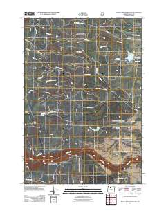
2011 Map of Rock Creek Reservoir
USGS Topo · Published 2011About this map
Rock Creek Reservoir and the adjacent Camp Cody define this corner of the eastern Cascades, where water management is central to the landscape. This 2011 survey illustrates a complex network of hydrologic infrastructure, including the Rock Creek Dam, Smarts Reservoir, and irrigation features like the Lost Boulder Ditch. The presence of Barlow Rd provides a historical link to the era of western migration, crossing through a terrain marked by named geographic landmarks like Bus Point and Boulder Point. The southern portion of the map is dominated by the winding path of the White River, fed by numerous springs including Immigrant Spring and Washburn Spring. This map reflects the enduring intersection of historic travel corridors and modern forestry and water utility, with roads such as Wamic Mill Rd and Linns Mill Rd hinting at the area's timber-related industrial history.
Find a feature on this map
32 named features on this map. Tap any name to fly to it.
Don’t see what you’re looking for? This feature index may not catch every label — zoom into the map to look around manually.
Map Details
Editions of this 2011 Rock Creek Reservoir Map
This is the sole edition of this map. No revisions or reprints were ever made.
Other maps of this area

1924 · Mount Hood
USGS Topo · 1:125,000

1927 · Mount Hood
USGS Topo · 1:125,000

1930 · Dufur
USGS Topo · 1:125,000

1934 · Dufur
USGS Topo · 1:125,000

1953 · The Dalles
USGS Topo · 1:250,000

1956 · The Dalles
USGS Topo · 1:250,000

1956 · Mt. Wilson
USGS Topo · 1:62,500

1957 · The Dalles
USGS Topo · 1:250,000

1962 · Rock Creek Reservoir
USGS Topo · 1:24,000
1962 · Foreman Point
USGS Topo · 1:24,000