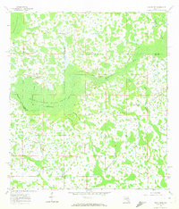
1960 Map of Rock Ridge
USGS Topo · Published 1972About this map
The settlement of Rock Ridge serves as the focal point of this Central Florida landscape, situated near the Sumter Co Polk Co and Lake Co Polk Co boundaries. This territory is defined by the expansive Withlacoochee River Swamp, where the Withlacoochee River winds through dense terrain alongside locally named features like Hart Hammock and Strand Hammock. The human imprint on this marshy environment is marked by the Little Flock Ch and a network of several alignments of the Old Railroad Grade, which suggest a history of timber extraction or earlier industrial transport through the wetlands. Drainage patterns are meticulously documented through systems such as Cumbee Drain, Mattress Drain, Pony Creek, and Devils Creek Swamp, illustrating the complex hydrology of the region before modern development patterns fully took hold.
Find a feature on this map
16 named features on this map. Tap any name to fly to it.
Don’t see what you’re looking for? This feature index may not catch every label — zoom into the map to look around manually.
Map Details
Editions of this 1960 Rock Ridge Map
4 editions found
Other maps of this area

1944 · Providence
USGS Topo · 1:31,680

1944 · Polk City
USGS Topo · 1:31,680

1944 · Socrum
USGS Topo · 1:31,680

1955 · Plant City
USGS Topo · 1:250,000

1955 · Orlando
USGS Topo · 1:250,000

1957 · Orlando
USGS Topo · 1:250,000

1958 · Orlando
USGS Topo · 1:250,000

1958 · Plant City
USGS Topo · 1:250,000

1959 · Plant City
USGS Topo · 1:250,000

1959 · Lake Nellie
USGS Topo · 1:24,000