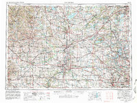
1958 Map of Rockford
USGS Topo · Published 1981About this map
The Rock River valley serves as the central artery for this regional survey, connecting industrial hubs like Rockford and Janesville across the Illinois-Wisconsin border. This late-1970s revision of a 1958 base map illustrates the transition from traditional rail-dependent manufacturing centers to a sprawling highway-based economy, with Interstate 90 carving through the agricultural heartland. The landscape is defined by its glacial heritage, featuring the distinct topography of the Kettle Moraine and the broad, fertile expanse of the Big Foot Prairie. In the southeast, the early suburban growth of the Chicago metropolitan area begins to encroach near Elgin and Crystal Lake. Meanwhile, the recreational clusters around Lake Geneva and Lake Koshkonong provide a counterpoint to the working river landscapes of the Pecatonica River and Sugar River. The dense network of the Chicago and North Western railroad still links smaller dairy and trade towns like Monroe and Harvard.
Find a feature on this map
350 named features on this map. Tap any name to fly to it.
Don’t see what you’re looking for? This feature index may not catch every label — zoom into the map to look around manually.
Map Details
Editions of this 1958 Rockford Map
4 editions found

Other maps of this area

1889 · Evansville
USGS Topo · 1:62,500

1890 · Madison
USGS Topo · 1:62,500

1890 · Sun Prairie
USGS Topo · 1:62,500

1890 · Stoughton
USGS Topo · 1:62,500

1891 · Waterloo
USGS Topo · 1:62,500

1891 · Koshkonong
USGS Topo · 1:62,500

1891 · Bayview
USGS Topo · 1:62,500

1891 · Riverside
USGS Topo · 1:62,500

1891 · Clinton
USGS Topo · 1:62,500

1891 · Muskego
USGS Topo · 1:62,500