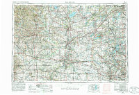
1958 Map of Rockford
USGS Topo · Published 1986About this map
Rockford and its neighboring industrial centers along the Rock River define this regional landscape during a period of significant growth. The map illustrates the dense connectivity between Janesville, Beloit, and Freeport, showcasing the complex rail networks of the Chicago Milwaukee St Paul and Pacific and Chicago and North Western railroads. Beyond the urban centers, the geography is marked by the distinct glacial features of the Kettle Moraine and numerous water bodies such as Lake Koshkonong and Lake Geneva.
Find a feature on this map
121 named features on this map. Tap any name to fly to it.
Don’t see what you’re looking for? This feature index may not catch every label — zoom into the map to look around manually.
Map Details
Editions of this 1958 Rockford Map
4 editions found

Other maps of this area

1889 · Evansville
USGS Topo · 1:62,500

1890 · Madison
USGS Topo · 1:62,500

1890 · Sun Prairie
USGS Topo · 1:62,500

1890 · Stoughton
USGS Topo · 1:62,500

1891 · Waterloo
USGS Topo · 1:62,500

1891 · Koshkonong
USGS Topo · 1:62,500

1891 · Bayview
USGS Topo · 1:62,500

1891 · Riverside
USGS Topo · 1:62,500

1891 · Clinton
USGS Topo · 1:62,500

1891 · Muskego
USGS Topo · 1:62,500