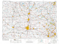
1958 Map of Rockford
USGS Topo · Published 1974About this map
The Rock River valley serves as the central spine for this regional study, connecting the industrial hubs of Janesville, Beloit, and Rockford. This mid-century landscape is defined by its sophisticated transportation network, where major rail lines like the Chicago and North Western and Chicago Milwaukee St Paul and Pacific intersect with a burgeoning highway system including U.S. 20 and U.S. 51.
Find a feature on this map
286 named features on this map. Tap any name to fly to it.
Don’t see what you’re looking for? This feature index may not catch every label — zoom into the map to look around manually.
Map Details
Editions of this 1958 Rockford Map
4 editions found

Other maps of this area

1889 · Evansville
USGS Topo · 1:62,500

1890 · Madison
USGS Topo · 1:62,500

1890 · Sun Prairie
USGS Topo · 1:62,500

1890 · Stoughton
USGS Topo · 1:62,500

1891 · Waterloo
USGS Topo · 1:62,500

1891 · Koshkonong
USGS Topo · 1:62,500

1891 · Bayview
USGS Topo · 1:62,500

1891 · Riverside
USGS Topo · 1:62,500

1891 · Clinton
USGS Topo · 1:62,500

1891 · Muskego
USGS Topo · 1:62,500