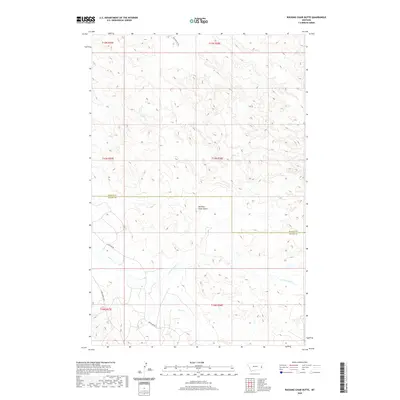
2020 Map of Rocking Chair Butte
USGS Topo · Published 2020About this map
Rocking Chair Butte stands as the central landmark of this corner of the Montana High Plains, straddling the border of Wibaux and Fallon counties. This landscape is defined by the drainages of Cedar Creek and Cabin Creek, which carve through the terrain as part of the region's complex hydrological network. The cattle-ranching and oil-exploration history of the area is etched into the map via a sparse network of service roads, including the aptly named Bar Nothing Road and Anticline Road. The latter suggests the geological importance of the region, which is situated atop the Cedar Creek Anticline, one of the most significant petroleum-producing structures in the northern plains. This 2020 survey captures the modern cattle-and-resource economy where public lands and private holdings intersect along these remote county lines.
Find a feature on this map
14 named features on this map. Tap any name to fly to it.
Don’t see what you’re looking for? This feature index may not catch every label — zoom into the map to look around manually.
Map Details
Editions of this 2020 Rocking Chair Butte Map
This is the sole edition of this map. No revisions or reprints were ever made.
Other maps of this area

1953 · Miles City
USGS Topo · 1:250,000

1957 · Miles City
USGS Topo · 1:250,000

1958 · Miles City
USGS Topo · 1:250,000

1981 · Lawrence Creek East
USGS Topo · 1:24,000

1981 · Lawrence Creek West
USGS Topo · 1:24,000

1981 · Ayer Spring NE
USGS Topo · 1:24,000

1981 · Cap Rock
USGS Topo · 1:24,000

1981 · Rocking Chair Butte
USGS Topo · 1:24,000
1981 · Rush Hall Reservoir
USGS Topo · 1:24,000

1981 · Wibaux
USGS Topo · 1:100,000