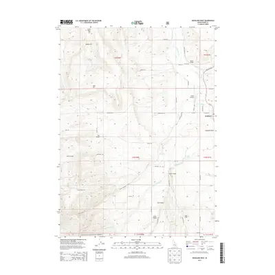
2013 Map of Rockland West
USGS Topo · Published 2013About this map
Rockland sits at the eastern edge of this agricultural and canyon landscape in Power County, where the valley floor meets the rising terrain of the Sawtooth National Forest to the south. The area is defined by a series of significant canyons and hollows, including Houtz Canyon, Dairy Canyon, and the appropriately named Dry Hollow, which carve through the high plateaus of Table Mtn and Little Table Mtn. Water management is central to the valley's settlement pattern, evidenced by the network of irrigation infrastructure such as US Ditch and the Lower W Ditch. Local hydrologic features like Warm Springs and Lupe Springs provide vital water sources in an otherwise arid environment. The map details a transition from the structured street grid of Rockland and nearby Rockland Valley to the more dispersed ranching and forestry roads like Powerhouse Rd and Dairy Springs Rd that climb into the higher elevations and ridges.
Find a feature on this map
55 named features on this map. Tap any name to fly to it.
Don’t see what you’re looking for? This feature index may not catch every label — zoom into the map to look around manually.
Map Details
Editions of this 2013 Rockland West Map
This is the sole edition of this map. No revisions or reprints were ever made.
Other maps of this area

1934 · Rockland
USGS Topo · 1:62,500

1937 · Rockland
USGS Topo · 1:62,500

1954 · Pocatello
USGS Topo · 1:250,000

1958 · Pocatello
USGS Topo · 1:250,000

1958 · Sublett
USGS Topo · 1:62,500

1959 · Yale
USGS Topo · 1:62,500

1971 · Rockland East
USGS Topo · 1:24,000
1971 · Indian Springs
USGS Topo · 1:24,000
1971 · Neeley
USGS Topo · 1:24,000

1971 · Rockland West
USGS Topo · 1:24,000