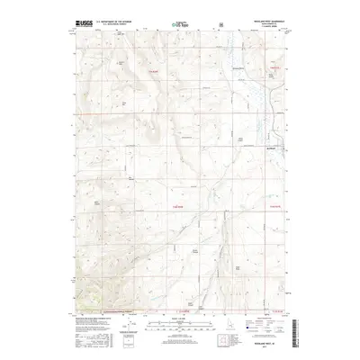
2017 Map of Rockland West
USGS Topo · Published 2017About this map
Rockland sits at the eastern edge of this agricultural and ranching landscape, where the Rockland Valley transitions into the high terrain of the Sawtooth National Forest. The map documents a sophisticated network of water management essential to the region, featuring the US Ditch, W Ditch, and the flow of Rock Cr and its various forks. Notable landmarks like Table Mtn and Little Table Mtn overlook a series of deep drainages including Dairy Canyon, Houtz Canyon, and Smith Canyon. A grid of rural roads, such as Powder House Rd and Creamery RD, connects scattered homesteads and provides access to critical water sources like Warm Springs and Lone Springs. The layout reveals how the local economy is tied to both the valley floor and the high summer ranges of the national forest.
Find a feature on this map
50 named features on this map. Tap any name to fly to it.
Don’t see what you’re looking for? This feature index may not catch every label — zoom into the map to look around manually.
Map Details
Editions of this 2017 Rockland West Map
This is the sole edition of this map. No revisions or reprints were ever made.
Other maps of this area

1934 · Rockland
USGS Topo · 1:62,500

1937 · Rockland
USGS Topo · 1:62,500

1954 · Pocatello
USGS Topo · 1:250,000

1958 · Pocatello
USGS Topo · 1:250,000

1958 · Sublett
USGS Topo · 1:62,500

1959 · Yale
USGS Topo · 1:62,500

1971 · Rockland East
USGS Topo · 1:24,000
1971 · Indian Springs
USGS Topo · 1:24,000
1971 · Neeley
USGS Topo · 1:24,000

1971 · Rockland West
USGS Topo · 1:24,000