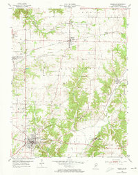
1955 Map of Rockville
USGS Topo · Published 1973About this map
Rockville serves as the central hub of this mid-century Indiana landscape, where the intersection of the Pennsylvania and Baltimore and Ohio railroads defines the regional transport network. The map reveals a high concentration of family and community landmarks, particularly across the townships of Penn and Washington. Genealogists will find a dense distribution of rural burial sites, from Rawlings Cemetery in the north to the Memory Garden Cemetery near the county seat. The presence of the State Sanatorium and the 4-H Club Fairgrounds indicates a community with established social and medical infrastructure. Smaller settlements like Annapolis, Bloomingdale, and Judson are connected by a system of creeks including Roaring Creek and Raccoon Creek, which dictate the local topography and placement of early roads.
Find a feature on this map
40 named features on this map. Tap any name to fly to it.
Don’t see what you’re looking for? This feature index may not catch every label — zoom into the map to look around manually.
Map Details
Editions of this 1955 Rockville Map
2 editions found
Other maps of this area

1948 · Wallace
USGS Topo · 1:24,000

1949 · Alamo
USGS Topo · 1:24,000

1951 · Mecca
USGS Topo · 1:24,000

1951 · Mansfield
USGS Topo · 1:24,000

1952 · Catlin
USGS Topo · 1:24,000

1953 · Indianapolis
USGS Topo · 1:250,000

1955 · Rockville
USGS Topo · 1:24,000

1955 · Kingman
USGS Topo · 1:24,000

1955 · Montezuma
USGS Topo · 1:24,000

1956 · Indianapolis
USGS Topo · 1:250,000