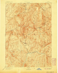
1894 Map of Rocky Bar
USGS Topo · Published 1906About this map
The high mountain settlements of Rocky Bar and Atlanta anchor this late nineteenth-century reconnaissance of the central Idaho wilderness. Located along the steep drainages of the South Fork and Middle Fork Boise River, these outposts were established during a period of intense mineral exploration and remote habitation. The map reveals a landscape dominated by the branching headwaters of the Boise River system, including the Yuba River and Little Queen River, where small camps like Graham and Junction Bar sat at the base of formidable peaks. To the southwest, the area around Trinity Mt. and Trinity Lake highlights the high-elevation terrain that challenged early surveyors. This sheet preserves the early jurisdictional boundaries of Boise, Elmore, and Alturas counties, showing the network of creeks and ridges that defined the mining districts of the 1890s.
Find a feature on this map
33 named features on this map. Tap any name to fly to it.
Don’t see what you’re looking for? This feature index may not catch every label — zoom into the map to look around manually.
Map Details
Editions of this 1894 Rocky Bar Map
5 editions found
Other maps of this area

1891 · Bear Valley
USGS Topo · 1:125,000

1892 · Mountain Home
USGS Topo · 1:125,000

1892 · Camas Prairie
USGS Topo · 1:125,000

1893 · Mountain Home
USGS Topo · 1:125,000

1893 · Bear Valley
USGS Topo · 1:125,000

1893 · Camas Prairie
USGS Topo · 1:125,000

1894 · Idaho Basin
USGS Topo · 1:125,000

1894 · Rocky Bar
USGS Topo · 1:125,000

1900 · Sawtooth
USGS Topo · 1:125,000

1909 · Garden Valley
USGS Topo · 1:125,000