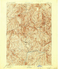
1894 Map of Rocky Bar
USGS Topo · Published 1925About this map
Rocky Bar and Atlanta serve as central points of activity in this high-altitude terrain of the 1890s, where the drainage of the South Fork Boise River and its various forks dictate the movement of people and commerce. The map, based on an 1891 survey, shows a landscape dominated by massive peaks such as Steel Mt., Trinity Mt., and Grey Lock Peak. The proximity of Junction Bar to the river forks suggests its role as a local transit node, while isolated settlements like Graham sit nestled near Silver Mt. in the northern reaches of Elmore County. Much of the territory falls within the boundaries of the Boise National Forest and Sawtooth National Forest, illustrating the early preservation of these timbered watersheds before modern infrastructure reached the interior of the Idaho mountains.
Find a feature on this map
28 named features on this map. Tap any name to fly to it.
Don’t see what you’re looking for? This feature index may not catch every label — zoom into the map to look around manually.
Map Details
Editions of this 1894 Rocky Bar Map
5 editions found
Other maps of this area

1891 · Bear Valley
USGS Topo · 1:125,000

1892 · Mountain Home
USGS Topo · 1:125,000

1892 · Camas Prairie
USGS Topo · 1:125,000

1893 · Mountain Home
USGS Topo · 1:125,000

1893 · Bear Valley
USGS Topo · 1:125,000

1893 · Camas Prairie
USGS Topo · 1:125,000

1894 · Idaho Basin
USGS Topo · 1:125,000

1894 · Rocky Bar
USGS Topo · 1:125,000

1900 · Sawtooth
USGS Topo · 1:125,000

1909 · Garden Valley
USGS Topo · 1:125,000